

�ЈD�W(w��ng)С����
һ�I���
������


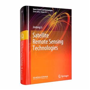

���] Satellite remote sensing technologies
���ߣ�Jindong Li[����]
�_(k��i)����
24cm
�(y��)��(sh��)��
23,421�(y��)
���(l��i)������I(y��)���g(sh��)�N(xi��o)����
��ܰ��ʾ��5�����D��(sh��)��Ҫ�������β؛���֞�ȫ�£����ܷ�/�o(w��)�ܷ⣩����(g��)�e�D��(sh��)Ʒ��8-9���¡��п�
�Є�����(bi��o)ӛ����P(p��n)�ȸ�����ȫԔ��(x��)Ʒ���f(shu��)��>>
�Є�����(bi��o)ӛ����P(p��n)�ȸ�����ȫԔ��(x��)Ʒ���f(shu��)��>>
���(l��i)���Ǖ�(sh��)����>
-
>
��·܇(ch��)����(ZINN�Ĺ�·܇(ch��)�S���c���B(y��ng)�ؼ�)
-
>
���w���·�O(sh��)Ӌ(j��)(��)

-
>
���ڂ�(g��)�Ի��O(sh��)Ӌ(j��)���Ե����ܽ�ͨϵ�y(t��ng)�P(gu��n)�I���g(sh��)
-
>
���Ӱٳ�:�F���ٔ�(sh��)����D����ɫ
-
>
ɽ�|��������������˾���g(sh��)�D(zhu��n)���c���g(sh��)��(chu��ng)�vʷ����(sh��)�Ї�(gu��)�ߵȼ��g(sh��)�������K��(1949��1961)�Ա����^(q��)������
-
>
�F·�C(j��)܇(ch��)��Ҫ.��������(d��ng)��(n��i)ȼ.����C(j��)܇(ch��)
-
>
���S̹�ĵ�������:���ڬF(xi��n)�������܌W(xu��)�Ć�(w��n)�}�c�}�j(lu��)

�������đ�(zh��n)��(ch��ng)���P(gu��n)����؛���c�Q(m��o)��](http://image31.bookschina.com/pro-images/250513gs/487100.jpg?id=81)
�ЈD�r(ji��):¥54.7
����ُ(g��u)��܇(ch��)
Satellite remote sensing technologies ���(qu��n)��Ϣ
- ISBN��9787568290647
- �l�δa��9787568290647 ; 978-7-5682-9064-7
- �b����һ���z�漈
- ��(c��)��(sh��)�����o(w��)
- ���������o(w��)
- ���ٷ��(l��i)��>
Satellite remote sensing technologies ����(sh��)��ɫ
Based on the overall design of the spaceborne remote sensing system��thi�� ��ook concisely summarizes China's experience in the spaceborne remote sensing system technology and its engineering application. Since the launch of a major science and technology project on high-resolution Earth observation system��China has made remarkable achievements in satellite remote sensing technology and major breakthroughs in the overall design and high-precision control of visible��infrared��hyperspectral��and microwave remote sensing satellites and in the processing and transmission of high-speed image data.China has launched the high-resolution remote sensing satellites such as Gaofen-l��Gaofen-����Gaofen-3��Gaofen-4��Gaofen-8��and Gaofen-9 in succession. These satellites have played an important role in the monitoring ofland and resources��the exploitation of mineral resources��the fine management of cities��the monitoring of traffic facilities��the survey of agricultural and forestry resources��and the recovery and reconstruction of disaster-hit areas��while enabling China's satellite remote sensing technology to achieve leapfrog development. Based on the overall design and flight verification of the above satellites��thi�� ��ook summarizes the state of the art of satellite remote sensing technology. The focus of thi�� ��ook is the mission analysis and overall design of remote sensing satellite system. Through the mission analysis and design��the mission objectives and requirements ��mission and tasks��functions and performance��etc.��proposed by the users are transformed into the overall design requirements and constraints on remote sensing satellite system��such as those on satellite orbit��load configuration and system composition. Meanwhile��the selection of carrier rocket and launch site is also discussed. Finally��the development trend of spaceborne remote sensing system in the future is presented by combing the future development trend of spaceborne remote sensing technology. Thi�� ��ook consists of 10 chapters. In Chap. 1��the basic knowledge on the general composition of satellite remote sensing system engineering��the physical basis of satellite remote sensing��the near-Earth space environment and its effects are introduced. In Chap. ����the mission characteristics of remote sensing satellite and its orbit design method are addressed. In Chap. 3��the overall design methods of visible panchromatic/multispectral remote sensing satellite systems are presented.In Chaps. 4 and 5��the overall design methods of infrared/hyperspectral remote sensing satellite systems are described��respectively. In Chap. 6��the overall design method of high-precision survey satellite system is given. In Chap. 7��the overall design method of synthetic aperture radar ��SAR�� remote sensing satellite system is elaborated on. In Chap. 8��the overall design method of microwave remote sensing satellite system is discussed. In Chap. 9��the overall design method of geosyn-chronous optical remote sensing satellite system is introduced. In Chap. 10��the future development trend of satellite remote sensing technology is given. Thi�� ��ook is mainly edited by Jindong Li and compiled and proofread by Jindong Li��Ting Li��Xiang Li��and Hezhi Sun. Chapter 1 was written by Chen Ni��Zhiping Zhang��and Jindong Li�� Chap. �� by Meili Huang��Qiao Zhao��and Hao Feng�� Chap. 3 by Ting Li��Zhen Li��and Jindong Li�� Chap. 4 by Chen Ni and Jindong Li�� Chap. 5 by Zhen Li��Lei Yao��and Jindong Li�� Chap. 6 by Xinwei Zhang�� Chap. 7 by Zheng Lv�� Chap. 8 by Mingming Xu�� Chap. 9 by Xianghao Kong�� and Chap. 10 by Dong Yang. The compilation of thi�� ��ook took more than �� years and received careful guidance and great support from the experts such as Academician of Chinese Academy of Engineering Peijian Ye��President of the China Academy of Space Technology ��CAST�� Hongtai Zhang��and Director of the Science and Technology Commission of the CAST General Division Yongfu Wang. Thi�� ��ook was also checked by Shiping Chen��Jijun Chang��Xiulai Hao��Shijun Ma��Wei Cai��Guojing Han��Guo Li��Zhenbo Cai��Tao Jin��Hong Jia��Yan Li��Jing Cao��Haitao Tang��Lei Yu et al��who put forward a lot of valuable suggestions during examination. The engineers from CAST General Division Xiaoheng Liang and Xiujuan Liang��together with the Springer editors��have done a lot of work on the publication of thi����ook. Here��the authors would like to express sincere thanks to them.
Satellite remote sensing technologies ��(n��i)�ݺ�(ji��n)��
�������l(w��i)���b�м��g(sh��)���DZ���������W(xu��)�������cSpringer Nature(li��n)�ϳ���D��(sh��)���l(w��i)���b�м��g(sh��)����һ�T(m��n)�C���ԵĿƌW(xu��)���g(sh��)��(y��ng)�������Ρ���(j��ng)��(j��)��܊�º����(hu��)�ȱ����I(l��ng)����ҕ��V����(sh��)��(j��)�ɼ��졢���؏�(f��)���B�m(x��)�^�y(c��)�����c(di��n)���ڇ�(gu��)���YԴ�ıO(ji��n)�y(c��)���_(k��i)�l(f��)����ͨ�O(sh��)ʩ�O(ji��n)�y(c��)����(z��i)�^(q��)�ؽ����r(n��ng)�֘I(y��)�YԴ�{(di��o)��ȷ�����в�����������á�ԓ��(sh��)��Ҫ�U���˸��(l��i)�b���l(w��i)��ϵ�y(t��ng)���O(sh��)Ӌ(j��)���b���l(w��i)���΄�(w��)���������g(sh��)���c(di��n)����(n��i)���漰�߷ֱ��ʺϳɿ����_(d��)�b���l(w��i)��ϵ�y(t��ng)�O(sh��)Ӌ(j��)���b���l(w��i)��ϵ�y(t��ng)��(g��u)���c���w��(g��u)�Ͳ����O(sh��)Ӌ(j��)�����وD��(sh��)��(j��)̎���c��ݔϵ�y(t��ng)�O(sh��)Ӌ(j��)���b���l(w��i)�����(d��ng)�����c��܉�z�y(c��)���g(sh��)���b���l(w��i)�ǿ��b�����c�(y��n)�C���g(sh��)��10�¡�ԓ��(sh��)ԭ��(chu��ng)�ԏ�(qi��ng)����(chu��ng)����ͻ������ӳ��������F(tu��n)�(du��)���l(w��i)���b���I(l��ng)��ƌW(xu��)�о����̌�(sh��)�`ȡ�õ��·������¼��g(sh��)�c�³ɹ�����Ҫ������b���l(w��i)�ǿ��w�O(sh��)Ӌ(j��)���l(w��i)�ǔ�(sh��)��(j��)�ɼ��c���������P(gu��n)��(zhu��n)�I(y��)�ĿƼ��ˆT�������Q���ˆT�ṩ����֧�֡�
Satellite remote sensing technologies Ŀ�
1 Fundamentals of Satellite Remote Sensing Technology
1��1 Introduction
1��2 Physical Basis of Satellite Remote Sensing
1��2��1 Electromagnetic Wave and Electromagnetic Spectrum
1��2��2 Solar Radiation Characteristics
1��2��3 Interaction Between Solar Radiation and Atmosphere
1��2��4 Interaction Between Electromagnetic Radiation and Target
1��3 Terrestrial Environment
1��3��1 Analysis of Satellite On-Orbit Environment and Effect
1��3��2 Charged Particle Radiation Environment
1��3��3 Vacuum
1��3��4 Neutral Atmosphere
1��3��5 Solar Electromagnetic Radiation
1��3��6 Solar Disturbance
1��3��7 Total Dose Effect of Space Radiation
1��3��8 Spatial Displacement Effect
1��3��9 Spatial Single Event Effect
1��4 Introduction to Satellite Remote Sensing Engineering System
Reference
2 Space Orbit Design of Remote Sensing Satellite
2��1 Overview
2��1��1 Classification by Orbit Altitude
2��1��2 Classification by Orbital Characteristics
2��2 Design Requirements and Characteristics of Remote Sensing Satellite Orbits
2��2��1 Orbit Design Analysis of Optical Remote Sensing Satellite
2��2��2 Orbit Design Analysis of Microwave Remote Sensing Satellite
2��3 Analysis and Design of Multi-mission Orbits for Optical Remote Sensing Satellite
2��3��1 Orbit Selection Principle
2��3��2 Satellite Multi-mission Orbit Design
2��3��3 Design of Satellite Multi-mission Orbit Parameters
2��3��4 Orbit Control
2��3��5 Orbit Control Fuel Consumption
2��3��6 Mission Application Strategy
2��3��7 Design of Initial Orbit Offset
2��3��8 Drift Characteristics of LTDN
2��3��9 Design of Resolution and Revisit Ability
2��4 Orbital Analysis and Design of Microwave Imaging Remote Sensing Satellite
2��4��1 Orbit Selection Principle
2��4��2 Orbital Parameter Determination
2��4��3 Mission Orbit Parameter
2��4��4 Initial Orbit Offset Design
2��4��5 Orbit Control
2��4��6 Observational Capability Analysis
2��4��7 LTDN Drift
3 Analysis and Design of High-Resolution Visible Spectral Remote Sensing Satellite System
3��1 Overview
3��1��1 Development Overview
3��1��2 Trend of Development
3��2 Demand Analysis and Technical Characteristics
3��2��1 Demand Analysis
3��2��2 Technical Characteristics of Visible Spectral Remote Sensing Satellite
3��3 Key Performance Indicators of Imaging Quality of Visible Spectral Remote Sensing System
3��3��1 Radiation Imaging Quality
3��3��2 Geometric Imaging Quality
3��4 Analysis and Design of Imaging Quality of High-Resolution Visible Spectral Camera
3��4��1 Overview of the Development of High-Resolution Visible Spectral Cameras
3��4��2 Key Design Elements of Visible Spectral Camera
3��4��3 Design of GSD and Camera Focal Length
����
4 Design and Analysis of Infrared Remote Sensing Statellite System
5 Design and Analysis of Hyperspectral Remote Sensing Statellite System
6 Design and Analysis of High-Precision Stereo Surveying and Mapping Satellite System
7 Design and Analysis of High-Resolution SAR Remote Sensing Satellite System
8 Design and Analysis of High-Precision Microwave Remote Sensing Satellite System
9 Design and Analysis of Optical Remote Sensing Satellite System on Geostationary Orbit
10 Development Prospect
չ�_(k��i)ȫ��
Satellite remote sensing technologies ���ߺ�(ji��n)��
����Prof.Dr.Jindong Li��doctoral supervisor and expert in the field of aerospace remote sensmg��currently works in Beijing Institute of Spacecraft System Engineering in China Academy of Space Technology as a chief designer in a certain area.Professor Li mainly engaged in the overall design of remote sensing satellites and research on spacecraft thermal control technology��and has successively served as the chief designer of several remote sensing satellites��a project expert in Major Basic Research on National Security��the chief scientist for National Defense 973 Program��and a member of Russian Academy of Cosmonautics by K.E.Tsiolkovsky.He has won 3 second prizes of the National Science and Technology Progress Award��4 first prizes��1 second prize��and 2 third prizes of the National Defense Science and Technology Award��and has published more than 80 academic papers in domestic and foreign journals and ����important academic conferences.
��(sh��)�����]
- >
�Ї�(gu��)���ڞ��K��߅���^(q��):�vʷ�c���(l��i)�W(xu��)����
- >
ɽ����(j��ng)
- >
��(j��ng)�䳣Մ
- >
���c�R
- >
�ؑ���(��i)���z
- >
��������~(y��)
- >
���������~����Փ/���С��(sh��)
- >
���c�؉�
���(l��i)���N(xi��o)